Dr. Thakuri is an Associate,Nepal
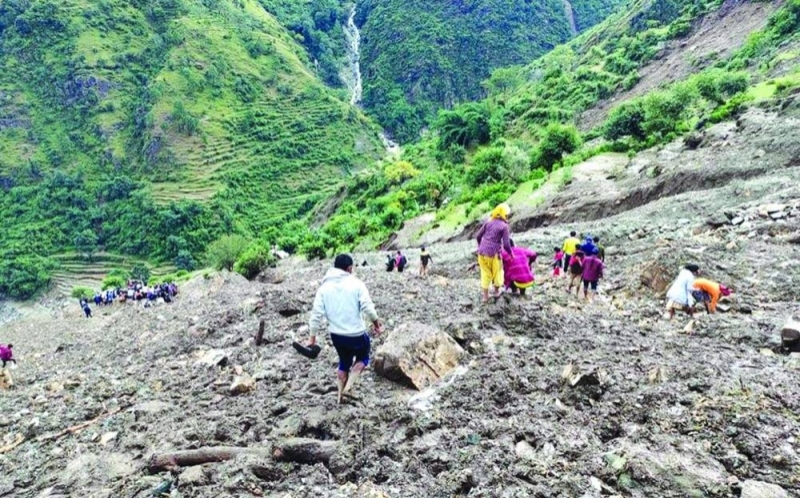
This year’s summer monsoon has again brought frequent landslides, flash floods, and debris flows across Nepal, with similar disasters unfolding across South Asia. Landslides, the downslope movement of earth, soil, and rock under the pull of gravity, are a natural process of mass redistribution. Yet, in Nepal, they pose a persistent and growing threat to lives, property, and infrastructure.
Landslides occur when loose soil layers accumulate atop solid bedrock and collapse once destabilised. While always a feature of mountain landscapes, their frequency and intensity have risen in recent decades due to erratic rainfall, warming temperatures, human disturbance, and Nepal’s fragile geology.
According to Nepal’s Disaster Risk Reduction Portal data (2011-August 2025), 4,629 landslides have been recorded, causing 1,906 deaths and 1,591 injuries, and damages worth more than Rs 20.66 billion. The rate of landslide incidents has accelerated dramatically – from 0.85 per 1,000 km² in 2011 to 3.36 in 2023, and a staggering 6.82 in 2024.
Nepal’s diverse landscape, from the Tarai plains to the Chure foothills, hilly midlands, and high mountains, is inherently vulnerable to slope failure. The steep terrains, coupled with young and fragile geology, makes the country naturally prone to landslides. Yet, monsoon rains amplify risks, particularly through wet landslides, while dry landslides also occur in other seasons.
Recent records show that in high-altitude zones, the melting of permafrost due to rising temperatures has likely increased rockfalls, avalanches, and slope instability. These events, unless they strike populated areas, often go undocumented, masking the true scale of the problem.
Several regions across Nepal have recently experienced repeated landslide disruptions, underscoring the severity of the crisis. On 8 August 2025, continuous rainfall triggered multiple landslides near Jahare Khet along the Prithvi Highway in Dhading, halting traffic for hours and paralyzing a vital transport link between Kathmandu and the western region.
In Salyan district, the Rapti Highway was blocked on 4 August after landslides struck Chorkhola. The Karnali Highway in Kalikot has also faced recurring blockages.
Eastern trade routes have not been spared either. The Araniko Highway, which connects Nepal with China through Sindhupalchok, was blocked on 7 August by a landslide at Ikhu.
Similarly, in early August, districts such as Gulmi, Palpa, and Kalikot witnessed multiple road blockages from heavy landslides. The persistence of such incidents shows how monsoon-triggered slides are paralysing mobility across both mid-hill and mountain roads.
Beyond transport disruption, landslides are directly threatening communities. In Baglung’s Nisikhola Rural Municipality, local authorities have identified more than 2,438 households at high risk of landslides and floods.
The September 2024 monsoon season also demonstrated the far-reaching impact of landslides and floods. Widespread disasters struck 21 districts, damaging over 50 health facilities and severely affecting access to essential services.
Nepal’s landslide risk is escalating under the dual influence of climate change and infrastructure pressures. A surge of monsoon rains, growing erratic and intense, fuels increased landslide frequency.
Moreover, glacial lake outburst floods (GLOFs) add another peril. In May 2025, a GLOF in Humla destroyed infrastructure and displaced about 32 villagers. In July 2025, another flood swept away the Friendship Bridge on the Bhotekoshi River, killing at least eight people, leaving dozens missing, and destroying hundreds of vehicles.
Regional trends mirror these challenges. South Asia’s monsoon is becoming more erratic, intensifying flooding and landslides. Glacial melt increases lake outbursts, elevating danger across the Himalayan region.
Nepal’s roads are often carved into unstable slopes, frequently left unpaved and lacking geotechnical safeguards. Earthmoving, drilling, and construction destabilise fragile land, compounding risks, especially during rainfall. Urban expansion without planning, unregulated infrastructure development, and exposure to earthquake-induced weakening of slopes further elevate vulnerability.
The path forward lies in adopting an integrated disaster risk management cycle that brings together science, engineering, planning, and policy. Generating scientific evidence through detailed mapping of landslide-susceptible zones and compiling historical disaster records can support to guide interventions. Preventive measures such as retaining walls, proper drainage, and slope stabilisation must be prioritised, alongside the establishment of early warning systems that utilise satellite data, ground sensors, and communication networks.
Equally critical is risk-sensitive land-use planning that discourages settlements in high-risk areas, supported by strong post-disaster preparedness through effective emergency response and community engagement. Finally, robust policy and implementation are essential; this means enforcing land-use regulations, making geotechnical assessments mandatory in infrastructure projects, and building financial resilience through insurance and reinsurance mechanisms to safeguard lives, livelihoods, and development gains.
Nepal’s vulnerability demands an urgent strengthening of its disaster infrastructure. Without investment in slope stabilisation, runoff management, and regulated construction, landslides will continue to create devastation.
The July-August monsoon months is the peak of monsoon rains in Nepal, precisely the period of highest landslide risk. Unless rainfall, terrain, and maldevelopment are effectively managed, we can expect continued and heightened disasters.
Dr. Thakuri is an Associate Professor at the Central Department of Environmental Science, Tribhuvan University, Kirtipur